
Smith Stevenson Road, Saskatchewan, Canada
Smith Stevenson Road
| Part I: Smith-Stevenson Road
Part II: Road Naming in Saskatchewan Part III: Grandma’s Memories |
Smith-Stevenson Road, Saskatchewan, Canada
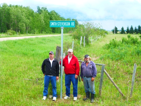
Where it may be that some of the records behind the naming of the roads and highways of Saskatchewan have been lost. One road has only recently been named. In early August 2015, folks came together to celebrate the naming of the “SMITH-STEVENSON” road in Saskatchewan. A family of homesteaders all farmed astride this right of way or in close proximity. By settling near to each other, an extended family could help one another at the busy season of harvesting before the snow arrived. Gordon Neish, a family member, has submitted this history of Smiths and Stevensons who homesteaded in the area.
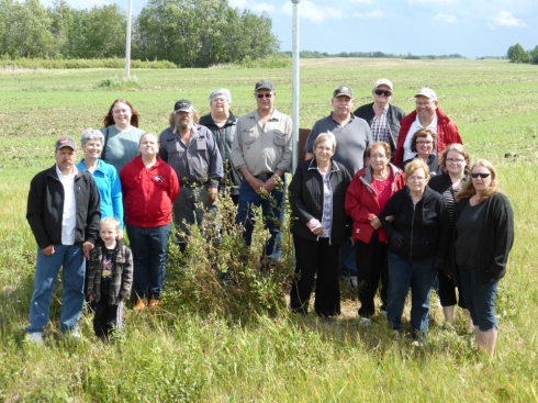
Smith Stevenson Road Naming Celebration
The Smiths (Schmidts)
The Schmidt family dates back to Captain Phillip Schmidt Born in Germany in 1725 immigrated to the United Stated in 1850. Rueben Waits Smith was his Great, Great Grandson.
The homesteading story begins in Illinois where Rueben Waits Smith and his wife Sophira Purdy purchased 80 acres of land in 1844. This is where they homesteaded and raised 10 children. Rueben and Sophira are buried on the original homestead. Their son George Israel Smith married Ida Mae Hodges daughter of another homesteader in the area. Seven on their eight children were born in Illinois with the youngest born in Jewell City Kansas, where they had moved to start new homesteads.
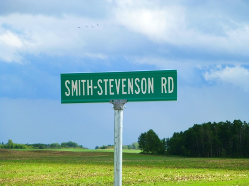
Smith – Stevenson Road, Saskatchewan, Canada
The Stevenson’s (Stephenson’s)
The Stevenson family dates back to Isaac Stevenson Sr. a mariner from England who immigrated to Canada in the early 1800’s. Isaac Sr. fought in the war of 1812.
He married Mary Hadley in Quebec City on July 13 1810. Their son Isaac Stevenson Jr. was born in 1814 his mother Mary died 1820.
Eventually Isaac Stevenson Jr. moved to Michigan where he married Mary Perry and had one son George Perry Stevenson. They then moved on to Jewell City Kansas where George Perry Stevenson married Susan Evelina Schoonover whose mother was a half Cherokee midwife. George and Susan had 3 children while living in Kansas.
The Smith’s and Stevenson’s
While in Kansas the children of both families attended the same one room school house, the Sweet Home School in Jewell City, Kansas. See attached school photo and records.
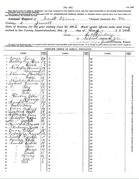
Jewell School District School Register
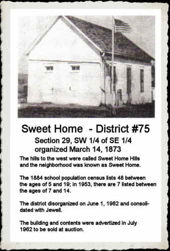
Sweet Home District 75
The two families moved to the Everett, Washington area in the early 1900’s and worked in the logging industry. In 1910 both families headed to Saskatchewan to file for homesteads in the Kermaria area.
| Saskatchewan placename | Legal land location |
| Kermaria | SW 16-41-19-W2 |
| Lac Vert | SW 2-41-18-w2 |
| Ambles | NE 16-40-20-W2 |
| Naicam | NW 2-40-18-W2 |
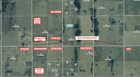
| HomesteaderName and Homestead Location | ||
| STEVENSON George Edward | SE34-40-19-W2 | Great uncle |
| SMITH George Elwood | NW27-40-19-W2 | Grandfather |
| SMITH George Israel | SW27-40-19-W2 | Great Grandfather |
| SMITH Henry Ernest | SE27-40-19-W2 | Great uncle |
| HOWE John | NE21-40-19-W2 | |
| STEVENSON Isaac | NW22-40-19-w2 | Great Great Grandfather |
| NELSON Bertha Amelia | NE22-40-19-w2 | Grandmother |
| STEVENSON George Perry | SW22-40-19-w2 | Great Grandfather |
| SMITH Lott Cabe | NE23-10-19-W2 | Great uncle |
Bertha Amelia Nelson maiden name Stevenson, she was a single mother we are not sure what happened to her husband. Because she was the soul provider for her son, she was allowed to homestead most women were not eligible for homestead land. She married George Elwood Smith in Aug 1912. Bertha’s sister Eliza married George’s Brother Henry also in Aug of 1912.
I have attached Eliza’s writing “Grandmas Memories” to her grandson telling of the trip from Washington to Saskatchewan and some of her homestead memories
Isaac Stevenson was, if not the oldest man to homestead in Saskatchewan certainly one of the oldest few at the age of 96.
The John Howe land is where the Bing school was built and where my mother attended school.
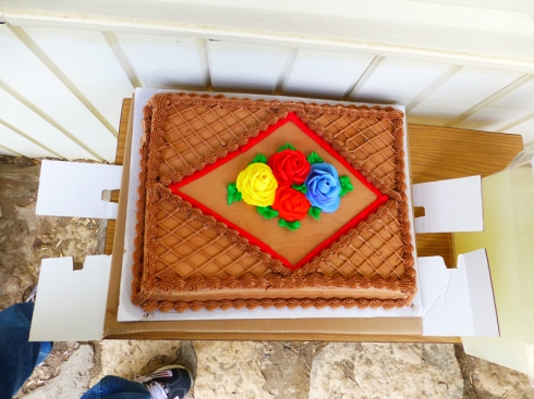
Smith Stevenson Road Naming Celebration Cake
Delving into the naming of Roads it was noted that it is intriguing a glimpse into history and determine why roads and highways have received the names they have been christened with. In Saskatchewan there has been an evolution in the roadways and highways. Although it may be possible that the derivation of some of the roadway names may be forgotten, it is a unique research project to delve into the nature of the roadway names, and follow regional trends. Were roadways named after surnames, given names, tribal names, a settlement, a natural feature, a park or a school? Was a road named after a town, village which no longer exists or perhaps after a landscape feature, a river or lake with a name that has since been changed. Hundreds of years ago “Donnacona, an Iroquoian leader, called an area centered on the present site of Québec City kanata, meaning “a cluster of dwellings”. This name began appearing on maps, giving rise to the Country name of Canada. In like fashion, the Cree word “kisiskâciwani-sîpiy”” for “swiftly flowing waters or swiftly flowing river” became the name for the province of Saskatchewan. Names of the roadways in the province of Saskatchewan may also have aboriginal, ethnic, royal origins, or they may honour community founders, saints, soldiers and politicians. Reflecting the birthright and heritage of the community, the name of a roadway may truly honour the prominent people and pioneers. A roadway name may reflect the inherited values, customs, legacy and qualities of the district.
| Bibliography:
From: Gordon Neish |
NOTICE: This Rootsweb/Ancestry.com page was saved on Internet Archive’s Wayback Machine by searching for the original page http://www.rootsweb.ancestry.com/~cansk/RoadsInSaskatchewan/!!! Rootsweb/Ancestry.com is down. It is the intention of this site to make this historical submission available to persons with a historical or genealogical interest.. There are no service charges or fees for personal use of these photographs, or transcription services and use of this site constitutes your acceptance of these Conditions of Use. These electronic pages and photographs are under copyright may NOT be reproduced in any format for profit. Persons or organizations desiring to use this material commercially, must obtain the written consent of the copyright holders and submitter: Gordon Neish and contact Saskatchewan Gen Web Webmaster, Julia Adamson with proof of this consent. .
copyright © Web Publish Date: Fri Dec 18 2015 All Rights Reserved
Many thanks are extended to Gordon Neish for this submission share online.
Tribute to Gordon Neish July 20, 1954 – June 14, 2020 You Tube
| See also Grandma’s Memories
Other submissions by Gordon Neish |
Rural Municipality of Pleasantdale No 398, Gordon Neish, Kermaria SW 16-41-19-W2, Lac Vert SW 2-41-18-w2, Ambles NE 16-40-20-W2, Naicam NW 2-40-18-W2Saskatchewan, Canada, Saskatchewan, Saskatchewan, Canada, photographs, photos, Kermaria SW 16-41-19-W2, Lac Vert SW 2-41-18-w2, Ambles NE 16-40-20-W2, Naicam NW 2-40-18-W2, STEVENSON George Edward, SE34-40-19-W2, Great uncle,
SMITH George Elwood , NW27-40-19-W2, Grandfather,
SMITH George Israel , SW27-40-19-W2, Great Grandfather,
SMITH Henry Ernest, SE27-40-19-W2 , Great uncle,
HOWE John, NE21-40-19-W2 , ,
STEVENSON Isaac , NW22-40-19-w2 , Great Great Grandfather,
NELSON Bertha Amelia , NE22-40-19-w2, Grandmother,
STEVENSON George Perry, SW22-40-19-w2 , Great Grandfather,
SMITH Lott Cabe , NE23-10-19-W2, Great uncle, Smith Stevenson Road,


