Tag Archives: village

Saskatchewan Cemeteries photographed and transcribed online

27 Oct

Ron Isherwood October 09, 1946 – August 09, 2017 enjoyed working on his Saskatchewan Cemeteries Project, and he also had enjoyed doing genealogy research.  Thank you very kindly to the many contributions made by Ron Isherwood, and for his dedication to the Saskatchewan Cemeteries Project, indeed.

burial cemetery cross daylight

The Saskatchewan Cemeteries Project which is now restored and operational online after the hiatus between December 2017 and September 2018.  The Saskatchewan Cemeteries Project is not being updated after 2017, but is kept online in an archived status thanks to Ancestry.com Rootsweb.


NOTE  There are a large number of organizations who are currently compiling cemetery information online which can be viewed at https://sites.rootsweb.com/~cansk/Saskatchewan/cemetery.html

The Canada Gen Web Cemetery Project – Saskatchewan Cemetery Project is a separate project from Ron Isherwood’s Saskatchewan Cemeteries Project and the Canada Gen Web Cemetery Project – Saskatchewan Cemetery Project features submitted transcripts searchable by ancestor’s name for all of Canada or Saskatchewan or by cemetery! Check out this cemetery transcriptions/photographs online project.

Ancestor Recognition Project – Cemetery Preservation: Online Cemetery Digitization courtesy of the Sask Gen Web Project

Online Historical Map Digitization Project

27 Oct

The Online Historical Map Digitization Project https://sites.rootsweb.com/~canmaps/ is now back online. This website was offline between December 2017-September 2018, however the Rootsweb/Ancestry.com IT department has returned the data online, restored and preserved.  Thank you for  your patience.

activity adventure blur business

New maps are expected to go online at the Online Historical Map Digitization Project https://sites.rootsweb.com/~canmaps/ so check this link periodically

Some of the maps and information online as of October 2018 are

Ethnic Bloc Settlements – Atlas of Saskatchewan

1862 Boundaries – Atlas of Saskatchewan

1882 Boundaries – Atlas of Saskatchewan

1895 Boundaries – Atlas of Saskatchewan

1904 Survey of the Dominion of Canada Maps

1905 Boundaries – Atlas of Saskatchewan

1907 Survey of the Dominion of Canada Maps

1910 Census Atlas of the World

1911 Alberta, Saskatchewan Atlas Maps

1911 and 1912 Maps of School Districts in Saskatchewan

1914 Department of Mines Geological Survey, Alberta, Saskatchewan, Manitoba

1914 Key West Rural Municipality 70, Saskatchewan Map

c1916 Cummins Maps, detailed quarter sections of Saskatchewan partial coverage of province

1917 Scarborough’s New Map of Saskatchewan
showing Judicial Districts, Land Registration Districts, Municipalities, Townships and Sections,
Cities (with populations), Villages (populations), Post Offices and Stations, Railway lines with Distances between Stations.

1919 Waghorn’s Railway Guide, Alberta, Saskatchewan, Manitoba

Early Rural Municipality of Turtle River 469, Saskatchewan Historical Homesteader Map

Early Regina, Saskatchewan city map

Early Scandinavian Canada Land Company Map for the area North of Canora, Saskatchewan

Early Stovel’s Pocket Map of Saskatchewan

1922 Gazetteer of United States. and Canadian Railroads

1922 New World Atlas and Gazetteer

1924 Saskatchewan Wheat Pool Map

1924 Rand McNally Indexed Pocket Map

1925 Waghorn’s Railway Guide and Maps, Alberta, Saskatchewan, Manitoba

1925 Saskatchewan Highway Map

c1935-1940 CNR Railway Map Western Canada

1935 Saskatchewan – Regina Sheet [Southern Saskatchewan] Department of mines map

1941 Waghorn’s Railway Guide and Maps, Alberta, Saskatchewan, Manitoba

1947-48 Saskatchewan Wheat Pool Map

1948 Waghorn’s Guide and Maps, Alberta, Saskatchewan Manitoba, Ontario

1950-51 Saskatchewan Wheat Pool Map

1952-53 Saskatchewan Wheat Pool Map

1954 Canadian National Railways Western Lines Map (Western Canada)

1954 Saskatchewan Government Insurance Highway Map of Saskatchewan
issued in cooperation with the Department of Highways and Transportation. Canada. 1954.

1984 Saskatchewan Wheat Pool Map

Canadian National Railway CNR Alphabet Railway Placenames Listing.

Frequently asked questions about the Online Historical Map Digitization Project and the individual maps

1921 Canada census : Place of Habitation : Rural Municipalities [RM]

Where were Saskatchewan homesteads located?

How do I locate my ancestor’s home town?

Maybe the Ghosts will rise again! – A look at Saskatchewan’s Ghost Towns

How do the Saskatchewan 2011 Canadian Census Statistics Compare to History?

Visiting your Ancestor’s Homestead – Planning a summer vacation?

Locate Your Saskatchewan Place-name

8 Nov Genealogy Research
Genealogy Research

Genealogy Research

Is it truly Irksome to search and research for the ancestral placename, and come up empty in the middle of your genealogical research? What are some hints and tips for discovering the place recorded from oral history, ancestral correspondence or on primary source documents? Out of the chaos can, indeed, come clarity and resolution by following the next few steps for ancestral place name research in the province of Saskatchewan, Canada.

    • First note the date of the document. Correspondence or documents dated before 1905 would refer to a place name of the North West Territories, as Saskatchewan did not become a province until 1905. In the North West Territories after 1882 there were three provisional districts , known as;
      1. Assiniboia, Assa
      2. Saskatchewan, Sask.
      3. Athabasca (Athabaska)

      The boundaries for the NWT and for the provisional districts are different from the contemporary province of Saskatchewan, and had some overlaps with Manitoba and Alberta.

    • Abbreviations for the province changed, Saskatchewan was once Sask., and now is SK. Canada was Can. and is now CA. The North West Territories has always been NWT, unless in French, in which case it is Territoires du nord-ouest; T.N.-O. There is a placename, currently the provincial largest city called Saskatoon without abbreviation not to be confused with Saskatchewan.
    • if it is the 1921 Census, then the place of habitation recorded by the enumerator is likely the Rural Municipality
    • In the early pioneering days, travel by horse and cart, meant that places were much closer together. With the advent of paved highways and motorized vehicles, urban centres grew, and smaller rural placenames folded away. Historic places such as Copeau may be found on historic maps, on the Canadian Library and Archives Post Offices website, or in one of the placename books published by Bill Barry, such as Geographic Names of Saskatchewan.
    • Searching for the ancestral name in homestead listings will determine the legal land location. Using this information, turn to an historic map to view the neighbouring sidings, post offices, elevators and placenames on the railway lines.
    • Be aware that placenames may have changed names over the course of time. This Analysis of Saskatchewan Placenames lists a few of these name changes.
    • Another fabulous repository would be cemetery listings which are coming online. These databases not only list the cemeteries, but usually closest locality and the Rural Municipality. The Saskatchewan Genealogy Society has listed over 3,000 cemeteries, and has two separate listings online
    • Pioneers often referred to their locale by the One room school house district in which they resided. The Sk One Room Schoolhouse project has close to 6,000 school district names with their locations.

So get creative and when looking up a place name on correspondence, in the released census or in birth, marriage or death certificates use some of the helpful hints above to locate where your ancestor resided in Saskatchewan. Genealogy research should not be an irksome task, make sense from the chaos, and get past your brick wall with success.

~written by Julia Adamson webmaster Sask Gen Web

Every man is a quotation from all his ancestors.

Like branches on a tree, our lives may grow in different directions yet our roots remain as one.

Landmarks and Geophysical Saskatchewan Placenames. Quiz Two.

29 Jun

Loyal and True KISS

Landmarks and Geophysical Saskatchewan Placenames.

This is an additional bit of fun. Following up on the previous Saskatchewan placenames quiz Here is yet another.

In the early days of the northwest plains when Saskatchewan was named Rupert’s Land or the North West Territories, travel followed animal trails on foot, horseback, or ox-drawn Red River cart. Egress was supplemented by bull boat and canoe over rivers and lakes. During these days, there were sparse settlements and no highway signs. Travelers identified their journey by geophysical features. The earliest resting stops, and settlements were generally speaking named after these landmarks.

Quiz Two.

Directions: Complete the quiz by identifying a Saskatchewan placename that best fits each clue.

1. Algae, Water basin.

2. Sight, Summit.

3. Grand earth.

4. Rapid, Waves.

5. Expansive panorama.

6. A bend or half turn.

7. Gigantic, Watercourse.

8. Colour, Meadow.

9. Diminutive Mountains.

10. Colour, Soil.

Give your hand at these crossword type puzzlers, and the answers will be published with the next entry! In taking time to do a fun and relaxing puzzle such as this one, not only does it stimulate the brain cells, but it also helps identify great resources in the way of finding out the names of Saskatchewan’s several placenames.

The geophysical features of Saskatchewan change between the grasslands, the aspen parkland and north of the tree line. Each biome has its own distinct water features, steppe, and hilly areas which were noted by early travelers as navigational aids. These changed slowly in the course of geological evolution, and were very reliable markers.

Following the fur trade era, the ecosystem was still invaluable to agricultural entrepreneurs. Settlers heeding Clifford Sifton‘s immigration call to the “Last Best West” would settle in areas where the soil types were similar to their home land. The agricultural methods and implements brought over on the long journey then met with success. A homesteader could fill out an Application for Entry for a Homestead, a Pre-emption or a Purchased Homestead. If the land was unsuitable the pioneer could file a Declaration of Abandonment with the provincial land titles office. Not only immigration settlers used the terrain and soil type to select a site, but aboriginal peoples would choose a reserve site similarly when signing a First Nations Treaty. Land agents traversing the plains by train would also check out the earth type which may be suitable to sell to large numbers of prospective clients.

Try to uncover the names of these Saskatchewan’s places. It may be helpful to use the Search Saskatchewan Placenames web page or perhaps one of the several map indexes at the Online Historical Map Digitization Project. Other resources would include the Saskatchewan One Room School House Project, or a reference chosen from the general Map Resources. Any number of atlases, gazetteers, census, or books may also be of assistance offering up some clues to these puzzlers.

Saskatchewan’s naming patterns are intriguing and convoluted, and to make matters easier Natural Resources Canada has published several helpful web pages amongst them Geographical Names. Try your hand at traveling via your arm chair discovering the various features of Saskatchewan’s landscape as did the forefather’s of this province. In this way discover a bit more of the surroundings for the early Coeur de Bois, First Nation and fur trading traveler.

________________________________________________________________________________

For more information:

•Saskatchewan One Room Schoolhouse Project

•Online Historical Map Digitization Project

•Search Saskatchewan Placenames

•How do I locate my Ancestors Home Town in Saskatchewan?

•Maybe the Ghosts Will Live Again
Saskatchewan Ghost Towns…

________________________________________________________________________________

Related Posts:

•The Value of Standardizing Placenames for Genealogists. First Quiz Answers.

•Test Your Knowledge of Saskatchewan’s Placenames. First Quiz.

•What can be found at the NEW Saskatchewan Provincial Archives website?

•The Era of Saskatchewan One Room Schoolhouses

•Why were Canadian “Last Best West” homesteads created?

•Love and Marriage in Saskatchewan- a comprehensive guide

•How did pioneers travel to their prairie homesteads?

•Why were Canadian “Last Best West” homesteads created?

•How to locate birth, marriage and death certificates in Saskatchewan, Canada

•Are there genealogy sites that can compete with Ancestry.com?

________________________________________________________________________________________

Follow me on Word Press, Blogger, Facebook, Flickr, Twitter, Tumblr, Live Journal, Sask Gen Web Ancestry.com and Flickriver

________________________________________________________________________________________

Aum_Kleem - View my most interesting photos on Flickriver

________________________________________________________________________________

Buy my work

Test Your Knowledge of Saskatchewan Placenames

7 Jun

Graceful Delight

This will be just a bit of fun. Genealogists start with what is known and work towards the unknown uncovering facts related to dates, places and people (names). Try to uncover the names of these Saskatchewan places. It may be helpful to use the Search Saskatchewan Placenames web page or perhaps one of the several map indexes at Online Historical Map Digitization Project. Other resources would include the Saskatchewan One Room School House Project, or a reference chosen from the general Map Resources. Any number of atlases, gazetteers, census, or books may also be of assistance offering up some clues to these puzzlers.

1. The name of a bush.

2. The name of a berry.

3. A male duck.

4. A good luck symbol.

5. To attempt.

6. An historic Canadian Prime Minister.

7. Woodworker.

8. Parliamentary assembly.

9. Heavenly, Bluff.

10. Coffee.

Give your hand at these crossword type puzzlers, and the answers will be published with the next entry! In taking time to do a fun and relaxing puzzle such as this one, not only does it stimulate the brain cells, but it also helps identify great resources in the way of finding out the names of Saskatchewan’s several placenames.

Saskatchewan is not divided neatly into counties nor parishes which are re-used for many and several divisions. Rather each separate entity, agency and newly formed group devises their own areas, regions and districts of Saskatchewan for their own purposes. Saskatchewan has rural municipalities which are the rural government regions providing similar civic responsibilities to large rural areas via reeves and councilors rather than mayor and aldermen. Then the province was also historically divided into school districts and school inspector districts which have given way to contemporary schools and school divisions again following new boundaries and regions. Starting again, every separate entity whether they are religions, health regions, genealogy or historical societies defines their own branches and areas. By accumulating clues to this puzzle, the given resources above may be used, or it may be a new here-to-fore resource comes forward to divulge the answer to the quest, which may also be the source needed on the genealogical journey in Saskatchewan.

While researching in Saskatchewan note that historically places were generally six miles apart which would be a good horseback ride in the early settlement of the north west. The early 1900s, which was about the same time Saskatchewan became a province, was a time of great growth as railways competed to lay rail across the prairies. Towns, sidings, and post offices sprang up like wildfire. The depression years of the 1930s initiated a trend away from the abandoned drought ridden farms to the city in search of employment. It was after World War II when automotive transport combined with new and improved straightened asphalt highways made egress across the vast province much easier. Gone were the oil surface highways “built on the square“. The ease of travel continued the trend of population shifting away from the smaller settlements towards the urban centers.

Historically there were about 3,000 seperate placenames, over 5,000 individual school district names, approximately 600 rural municipalities and these numbers are not inclusive of geographical feature names, federal electoral or provincial electoral districts. A genealogical baptismal record, letter of correspondence or birth certificate may indeed have recorded upon it a name no longer listed on contemporary maps. Following the standardization by Canada Post of placenames across the nation, duplicate naming was virtually eliminated. Places with a similar name elsewhere were asked to change their names. Placenames in Saskatchewan may have, indeed, undergone a name change for a plethora of reasons.

Saskatchewan’s naming patterns are intriguing and convoluted, and to make matters easier on this front, it is wonderful that there are resources online and in print presenting this etymological history in various lists, books, gazetteers, and websites.

________________________________________________________________________________

For more information:

•Saskatchewan One Room Schoolhouse Project

•Online Historical Map Digitization Project

•Search Saskatchewan Placenames

•How do I locate my Ancestors Home Town in Saskatchewan?

•Maybe the Ghosts Will Live Again
Saskatchewan Ghost Towns…

________________________________________________________________________________

Related Posts:

•What can be found at the NEW Saskatchewan Provincial Archives website?

•The Era of Saskatchewan One Room Schoolhouses

•Why were Canadian “Last Best West” homesteads created?

•Love and Marriage in Saskatchewan- a comprehensive guide

•How did pioneers travel to their prairie homesteads?

•Why were Canadian “Last Best West” homesteads created?

•How to locate birth, marriage and death certificates in Saskatchewan, Canada

•Are there genealogy sites that can compete with Ancestry.com?

________________________________________________________________________________________

Follow me on Word Press, Blogger, Facebook, Flickr, Twitter, Tumblr, Live Journal, Sask Gen Web Ancestry.com and Flickriver

________________________________________________________________________________________

Aum_Kleem - View my most interesting photos on Flickriver

________________________________________________________________________________

Buy my work

Maybe the Ghosts Will Live Again!

25 Feb

Second Spring

Maybe the Ghosts Will Live Again!

Try out Saskatchewan‘s newest Sunday afternoon tourism trend. Discover a part of Saskatchewan’s history and seek out an abandoned ghost town. Walk down main street of our pioneer’s community and imagine what life was like a century ago.

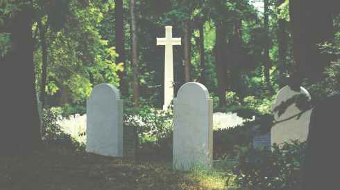
Why did the settlers arrive to settle here in this particular location? What was the community like, and how large did it get? How many children attended the one room school house, and how far did they travel? Did the community main street once boast a store, church, hotel and elevator? What were the stories behind the communities who are only remembered by their cemeteries? Were there once barn dances and Christmas socials at the schoolhouse? What occurred to cause the abandonment of the buildings at this site? What are the real life stories behind the ghost towns?

According to the Saskatchewan Atlas edited by J.H. Richards and K.I. Fung, they used the terms unincorporated hamlets and settlements in Saskatchewan. A settlement may disperse over a greater area than a hamlet, and a locality may refer to a settlement without post office or community.

Whereas, the Atlas of Saskatchewan Celebrating the Millenium Edition defines various unincorporated places in Saskatchewan. A hamlet has a population less than 100 persons, a locality has less than ten residents. A post office is defined by a rural post office site, and a railway point may be a siding or a junction along a rail line. An organised hamlet also has a population less than 100, however would have a chairman, members, and advisors who act for the community in a similar capacity to the role of a mayor or councillor in a city but on a smaller scale. A resort village is also served by a mayor, councillor and administrator similar to a town or village.

Both books define a locality as former communities which may only exist in historical documents, post cards, maps or the designated place, and these placenames were enumerated during census years as a part of the Rural Municipality (RM) rather than as an individual entity or locality.

A locality, or designated place without residents but with visible remains of civilization may, in fact, fit a definition of a “ghost town. Wikipedia goes further, “A ghost town is a town that has been abandoned, usually because the economic activity that supported it has failed or because of natural or human-caused disasters such as war.”

In Saskatchewan a community reaches city status with a population over 5,000; may incorporate as a town with a population over 500, and reaches town status with a population over 100.

Along the highways and roadsides of Saskatchewan still stand deserted homes, schools, businesses and churches of communities once bustling with hope and optimism of new dryland agriculture methods. The depression years coupled with the great drought of the dirty thirties saw a huge exodus from the rural settlements searching for economic prosperity in the cities. Especially hard hit was the area of Saskatchewan defined as the Palliser Triangle consisting of areas of badlands, sand dunes and semi-arid soil, and it is here that a span of highway has the moniker now of Ghost Town Trail, Saskatchewan.

Along with the abandoned buildings are the tales of ghosts, haunting figures and eerie sounds. One of the more famous tales in Saskatchewan is of the ghost train traveling near St. Louis, Saskatchewan. A devastating train derailment occurred as well as a fatal accident which laid claim to a pioneering family.

The textures and character of the abandoned buildings have spawned a cult of photographers roaming the countryside to historic ghost towns. The techniques vary from capturing the perfect sunset or sunrise shot, capturing a ghost town at night with innovative light painting techniques or perhaps a ghost town capture offers an opportunity to use high dynamic range HDR photography. Some photography excursions seek out a focal point such as an historic pool elevator, a heritage train station or rusty car in a cloudy summer landscape, a colourful autumn scene or a seasonal winter setting.

Defined perhaps as Saskatchewan’s current tourism craze, the Saskatchewan Heritage and Folklore Society SHFS, brings history to life. Plaques and points of interest demark heritage stories, historic searches for diamonds and rubies, or may regale how pioneers would move a whole village to be on the tracks if the railway did not go through town. In the roaring twenties Saskatchewan was at its height in terms of population rise. These horse and buggy days saw numerous settlements spring up approximately every five miles alongside the newly laid rail lines.

Besides creative commons sources such as Wikipedia, books have been published about this new tourism attraction of Saskatchewan Ghost Towns in Saskatchewan, Including: Armley, Saskatchewan, Cactus Lake, Saskatchewan, Island Falls, Saskatchewan, Zichydorf, Saskatchewan, the Fren, Ghost Town Stories of the Red Coat Trail: From Renegade to Ruin on the Canadian Prairies , Canada Ghost Town Introduction: Govenlock, Saskatchewan, List of Ghost Towns in Alberta, Lucky Strike, Alberta, Hallonquist, Saskatchewan , Ghost Towns in Saskatchewan: The French Counts of St Hubert, Saskatchewan, Ghost Stories of Saskatchewan , and More Ghost Stories of Saskatchewan . Films, for example Ghost Town Trail, Saskatchewan and documentaries on television have aired.

You may want to join this trend, popping out for a coffee on a lazy Sunday afternoon, traveling down a little used grid road to uncover a bit of Saskatchewan history. Program your GPS, look up a historical map of Saskatchewan, get the lay of the land, and head out. If you find an abandoned building do not trespass or venture forth inside a decaying building. Explore from a safe vantage point from public lands.

Saskatchewan ghost towns, a book researched by Kan Do Wheels and is now online to “tell why a community was born, lived and died”. Frank Moore, the author states that “people are returning to some of these towns and buying salvagable buildings…People are coming to realize the slick, future-shocked city life can’t meet their needs. And so they are looking for an alternative – a place where they can enjoy a sense of community, take charge of their lives, and know harmony with their environment.”

And to echo Moore, “Maybe the ghosts will live again!”
________________________________________________________________________________

For more information:

Saskatchewan One Room Schoolhouse Project

Online Historical Map Digitization Project

Search Saskatchewan Placenames

How do I locate my Ancestors Home Town in Saskatchewan?

________________________________________________________________________________

Related Posts:

What can be found at the NEW Saskatchewan Provincial Archives website?

The Era of Saskatchewan One Room Schoolhouses

Why were Canadian “Last Best West” homesteads created?

•Love and Marriage in Saskatchewan- a comprehensive guide

How did pioneers travel to their prairie homesteads?

Why were Canadian “Last Best West” homesteads created?

•How to locate birth, marriage and death certificates in Saskatchewan, Canada

Are there genealogy sites that can compete with Ancestry.com?

________________________________________________________________________________

“A man who is not afraid is not aggressive, a man who has no sense of fear of any kind is really a free, a peaceful man.” Jiddu Krishnamurti. All rights reserved. Copyright © Aum Kleem All my images are protected under Canadian and international authors copyright laws and may not be downloaded, reproduced, copied, transmitted or manipulated without my written explicit permission. Image: Second spring“Autumn is a second spring when every leaf is a flower.” ~ Albert Camus The images may, in fact, be licensed through Getty images. Peace and love be with you. Namaste.

________________________________________________________________________________________

Follow me on Word Press, Blogger, Facebook, Flickr, Twitter, Tumblr, Live Journal, Sask Gen Web Ancestry.com and Flickriver

________________________________________________________________________________________

Aum_Kleem - View my most interesting photos on Flickriver