1, 2, 3, 4 just a bit of Homestead Rapport.
Searching in the field for an ancestral homestead or legal land location requires a knowledge of meridians, four meridians. Four? you say, yes, historically genealogists applying themselves to Saskatchewan, Canada research may indeed, need to know about four meridians.
A homestead application form from the Provincial Archives of Saskatchewan or a certificate of land patent from the Canadian Library and Archives LAC would both have the legal land location of the pioneer homestead location showing the quarter, the section, township, range and meridian. These are survey notations, and the numbers for township, range and meridian can be found on Rural Municipality maps, and historic maps of the province. Land was also awarded as Métis scrip, and soldier settlement awards, however if this land location proved to be some distance from their family or prior residence it may have been sold. Land not suitable for agricultural development may have been abandoned, or farmers may have sought employment in an urban centre during the dirty thirties. Not all legal land locations became ancestral homes, indeed, however there are primary source documents for genealogy research which may prove useful even if the land were abandoned for whatever reason, or if the land was sold.
The Century Family Farm Award Program inaugurated 1981 by Saskatchewan Agriculture and Food for the 75th provincial anniversary (1980) to honour Saskatchewan’s farm families. Between 2007-2014 over 3,600 families received the award. “Farm and ranch families have played a significant role throughout our province’s history,” Agriculture Minister Bob Bjornerud said. “These Century Farm Family Award recipients continue to build on the traditions of their ancestors, bring new ideas and innovation to agriculture, and will be an essential part of Saskatchewan’s future.”source In 2010, 635 , over 300 (2007), over 350 (2013) and 85 families in 2016 were honoured by the Information Services Corporation (ISC) Century Farm Award. “The family farm has always been the backbone of Saskatchewan’s economy and has helped shape the rural traditions of our province,” Minister responsible for ISC June Draude said. “Homesteaders had a strong work ethic and today’s farm families have that same strength and character. I congratulate all recipients for reaching the centenary milestone.” source
The Rural Municipalities (RM) only occur in the southern portion of the province, the prairie, grasslands and aspen parkland eco-systems. The RMs occur where there is rural settlement upon. Agricultural land was surveyed during the Dominion Land Survey for homesteads. The RMs indicated on the map below have changed since their inception in the early 1900s. Those RMs larger than 18 square miles have subsumed adjacent RMs if the population was scarce, or to allow for uban centre expansion, &c. The Northern Municipality refers to the northern province ~ the Canadian shield, tundra, and boreal forest area~ an area not surveyed under the Dominion Land Survey system. Urban municipalities are towns, cities, hamlets with a separate civic government.

Province of Saskatchewan, Canada map after 1905 Adapted from Author Hwy43
Creative Commons Attribution 3.0 Unported license.
The first task is to determine the ancestral homestead or quarter section. This may be written on the birth certificate, in the census, upon the homestead application form or Western Land Grant Certificate (1870-1930).
For researching a very common surname, it may be beneficial to delimit the search by meridian of the neighbouring post office, rail siding, town or village to the ancestral farm. Use the Geographical Names of Canada, an historical map index, the post office database at LAC, Atlas of Saskatchewan by the University of Saskatchewan, or Geographic Names of Saskatchewan book by Bill Barry to find the legal land location of the nearby locality to narrow the search.
For the sake of example, perhaps the research results came up with these legal land locations from the Battle of Iwuy soldier research. Randomly selecting: Belt, John Henry Army 73427 Canadian Infantry (Saskatchewan Regiment) “A” Coy. 28th Bn. Residence “Little Red River Reserve”, Alingly, SK SE-17-51-27-W2, Enlistment, Prince Albert, SK, Died Thun-Saint-Martin. Military Medal Born: February 21, 1893 Darlington, England Son of Robert and Elizabeth Belt, of Alingly, Saskatchewan. The following land locations may not be relevant, and obtaining the source homestead document and conducting further comparison to oral history, and other documents are required for confirmation.
| Belt, John Henry |
SE 28 51 27 W2 |
| Belt, Robert |
NW 28 51 27 W2 |
| Belt, Elizabeth |
SE 28 51 27 W2 |
| Belt, James Victor |
SW 27 51 27 W2 |
| Belt, William Thomas |
SW, 28 51 27 W2 |
This study will focus on the above record for a Belt, John Henry Sout east quarter of section 28 township 51 range 27 West of the 2nd meridian.
Township can be abbreviated T, Tsp or Twp.
Range may be abbreviated R, or Rge.
Alingly, Saskatchewan at SE 17-51-27 W2 on the map is a nearby locale to SE 28-51-27 W2. The farm is within an acceptable distance to drive a horse and cart into town. Further to this, the surnames might also found on census, and in local history books. Homesteaders on application needed to prove up their land. The provincial archives online listings also indicate military personnel who received Soldier Settlement Grants. Homesteaders could cancel their application if they found the land unsuitable, if they procured occupation in town, &c. Soldier Settlement Grants, Scrip, and those homesteads which were successfully proved up, could be sold in private transactions. Whenever one ancestor is found in the listing, pay attention to those of the same surname farming nearby, – they be cousins, brothers, uncles, &c Family farmed together to helping each other in homestead duties, at seeding times and harvest.
So to locate the legal land location, look at an historical map or a Rural Municipality map, and find Alingly in this case. This is where the meridians come in handy. A meridian seeks to have congruency with the Geographic Coordinate System of latitude and longitude. Because the earth is a sphere, correction lines are built into the Dominion Lane Survey.
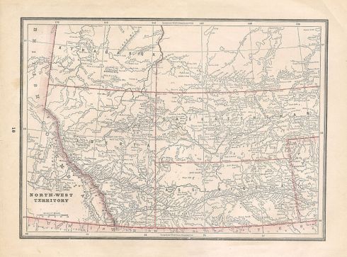
The first meridian is located in Manitoba and farms west and east of the “first” or “prime” meridian are those, of course in the province of Manitoba. Additionally Ranges 28, 29, 30 and 31 west of the first meridian are located in southern portion of the province of Saskatchewan as there is some overlap where the border comes across the meridian. There is an addendum here, perhaps the primary source document with the legal land location was dated 1870-1905, then the ancestor was indeed a resident of the North West Territories. To determine which provisional district of the NWT, the farm may have resided in, compare to the township and range numbers here.

1900 Map of Manitoba and the North-West Territories Creative Commons Attribution 2.0
(note the border north and west of the province of Manitoba does not correlate at all with the 1905 eastern border of Saskatchewan which is nearly true to the second meridian)
The second meridian is near the eastern limits of the province of Saskatchewan, and the entirety of homesteads west of the “second” meridian are all in the province of Saskatchewan.
The third meridian arrives next, and again, the entirety of homesteads west of the “second” meridian are all in the province of Saskatchewan.
The fourth meridian extends in conjunction with the Alberta and Saskatchewan border which was created in 1905. Before this time, land belonged to the North West Territories. The provisional districts of Assiniboia in the south, provisional district of Saskatchewan centrally located, and provisional district of Athabasca to the north had different boundaries not congruent with the fourth meridian. If the pioneer document was dated 1870-1905, then the homestead started up in the North West Territories. Check with the township and range numbers here to see which provisional district of the NWT the homestead may have fallen into.
Once the meridian is located on the map, travel west to locate the range number, and also ascend north along the listing of township numbers. For John Henry Belt go north to township 51, and go west of the second meridian to range 27. This locates the 6 mile by 6 mile township in which he farmed. If the map shows quarter sections then also find section 28 which is 1 mile by 1 mile, and know that John Henry Belt farmed the 1/2 mile by 1/2 mile quarter in the south east of this section. If the map chosen does not show sections, then realize that the township is divided into sections as shown here on the chart.
As the farm is at SE 28-51-27 W2 and Alingly is at SE 17-51-27 W2 it is seen that as the townships are divided into sections that the farm section number being 28, and the town being 17 does make the farm section about 1-1/2 miles north of Alingly and 1/2 miles to the west. Ordering a rural municipality (RM) map from the RM office indicates where contemporary highways are situated in relation to legal land locations. historical maps mostly indicate the rail system, so they would indicate where the farm was in relation to the rail lines.
To drive to the ancestral homestead, now convert the legal land location into Global Positioning System (GPS) coordinates using a handy online converter, and use this method to find the centre of the 1/2 mile by 1/2 mile quarter where this pioneer had farmed.
Country roads, take me home to the place I belong. ~ John Denver
Once driving in Saskatchewan, realize that Canadians have adopted the metric system in 1970, and distances and mileage is by kilometers and kilometer/hour. Without a GPS system the ancestral homestead will need to be found measuring miles traveled along the highway or grid road. A very quick way to get a good approximation and convert kilometers to miles is to multiply by 6 and move the decimal to the left one. For instance, a traffic sign posting a speed limit of 100 kilometers/hour is thus converted by multiplying by 6 (100 * 6 = 600), and then changing the decimal one backward arriving at 60 miles per hour. (an actual online conversion 100 km to miles is 62.1371) On an historic map showing miles, do the opposite, 10 miles divided by 6 would result in (10 / 6 = 1.6 and move the decimal) with a result of 16 kilometers. (an actual online conversion calculations shows that 10 miles is 16.0934 kilometers)
The other very handy item to know when traveling on Roads in Saskatchewan is to read the grid road signs! Range roads are those used when driving north or south, and township roads take the traveler in an east and west direction. Picturing the range lines on the map, will help to orient driving and using range road numbers in the field, and similarly with township lines and township roads.
The numbers on the signs are very handy, as they correlate to the Dominion Land Survey system and legal land coordinates.
Range road signs begin with the meridian number. To locate John Henry Belt’ homestead the range road signs would all begin with 2 ~ (his farm was SE 28-51-27 W2). Ranges increment every 6 miles in distance traveled. On the Range road sign, the next two digits are the range number. So to find this particular farm, the Range Road sign should indicate 27 as the next two digits following the 2. Now the last number on a Range road sign is how many miles into the range that the road has been laid down, these miles increment east to west, and can number up to 5. Examining how a township is split into one mile by one mile sections it can be ascertained that the SE quarter section 28 is 3 miles west of range road 27, situating the farm between Range road 2273 and Range road 2274.
A township road sign determines the road name when driving east or west, and the first number is the township number. All township numbers for the province of Saskatchewan begin at the United States and Canada international border (the 49 parallel), and the township numerals increment every 6 miles in a northerly direction. John Henry Belt farming at SE 28-51-27 w2 would have his farm along township road beginning with the numeral 51. As township numbers increment every 6 miles, the next numeral is the mile number within the township between 0 and 5 still increasing in value from the south to the north. Looking again at how a township is divided it can be ascertained that SE quarter section 28 is 4 miles north of township line 51; therefore John Henry Belt’s farm is has an allocation between township road 514 and township road 515.
Township lines or roads begin and end around geological features, and urban centres, and then continue north to the tree line. The Range lines or roads also extend straight as an arrow, and there is a lake or city, similarly, the range will continue along in the same way as a latitude or longitude line. Gravel roads, highways, and municipal roads can all have concurrency with township and range road numbering. Historically, there was allowance for a township road every mile, and a range road allowance was allocated every two miles.
So, whether determining the location for a homestead applied for in the North West Territories or in the province of Saskatchewan between 1905-1930, these insturctions should assist in arriving successfully at the pre-requisite destination. These driving instructions should also apply for any legal land location, as perchance the pioneering ancestors, or contemporary family may reside on an agricultural rural allotment with a township, range and meridian number. Settlers could also buy pre-emptions, land from colonization companies, from the railway companies or once they proved up their land, they were free to sell it on the open market.
Think on this. Imagine that the pioneer who crossed the ocean in a steamer and the journey took a few weeks. Arrival would very likely be an eastern port of Canada or the USA, and then progress overland would continue via rail to the closest stopping off point to their destination in the west. The transcontinental rail way was completed on November 7, 1885, and it traversed through the southern portion of the provisional district of Assiniboia, North West Territories. From this date onward rail companies established their own lines at various speeds and times throughout the province. Branch lines and main trunks traversed the North West Territories, continuing on after the Saskatchewan became a province in 1905. (In many cases the current highway thoroughfares run parallel to the main trunk line railway grade.) From the furthest point of the rail, the pioneer would disembark and begin walking. If a relative arrived ahead of time, the early settler may be met at the rail station by horse and cart or ox and buggy, and receive transport. An early purchase was conveyance.
After traveling around the countryside, the pioneer would need to find a iron marker placed between four monuments (pits) on an unclaimed section of land. The iron marker with the section number on it stands in the North East corner of the one mile by one mile section. The wise new-comer would need to compare the soil sample on this land with the soil of his home country to have the greatest success with his learned agricultural tillage methods and implements brought forward on the long journey. If the section and land was acceptable, the potential homesteader would then hasten to the land titles office, to fill out an application form, and lay down a $10 filing fee, returning to the land to begin his duties.
Imagine again, if you will, finding an iron post driven into the ground without asphalt roads, no GPS, absolutely not a road sign anywhere, nestled into the grasslands, or within the Trembling Aspen bluffs, and in the 1800s amid herds of buffalo. Consider, also this, the iron marker in the north west corner of the section bears Roman Numerals for section township and range. As this in this example, John Henry Belt homestead was SE 28-51-27 w2) the iron post would have read XXIV XXX XII. Early immigrants may have settled in ethnic bloc settlements to facilitate communication, agricultural harvesting work bees and settlement chores in proving up the land.
NOTE: It is always wise and prudent to contact the nearby locality before driving out to an ancestral homestead to learn how to make contact with the current owners. Ask at the regional library, museum, RM office, or town hall for advice. Seek to purchase an up to date RM map from the RM office. Consider buying an historical Cummins map from the Provincial Archives of Saskatchewan and marked herein the ancestor’s name. Phone the current land owner perchance with Mysask.com or Canada411. Do not trespass on private property or farm land without permission, ever. Such practices can, indeed, be detrimental and even fatal to livestock, devastating to crops and violate the landowners sensibilities and legal rights. Also many historical township roads and range roads do not exist anymore. With the straightening and paving of highways, and the advent of motorized travel, it is not necessary for the Ministry of Highways nor the RM to maintain each and every single range road and township road from the Dominion survey system so the roads may not exist anymore. That former road allowance may now be in a farmer’s field, or pasture land. That is why a contemporary RM map is so handy for this journey to the homestead.
FOR MORE INFORMATION:
Saskatchewan Provincial Standard System of Rural Addressing. Adapted by Saskatchewan Association of Rural Municipalities (SARM) Information Services Corporation. Regina, SK.
To find lands in the field part 1
To find lands in the field part 2
To find lands in the field part 3
Tags: ancestor, Charles Daniels, daily post, Discover Challenge, farm, homestead, kilometer, map, mile, North West Territories, postaday, Provisional Districts, quarter section, Radville, range number, Sask Gen Web, Saskatchewan, section, township, township number


 1954 Canadian National Railways Western Lines Map (Western Canada)


.jpg)
.jpg)